The RECETOX environmental database has worldwide use
What have RECETOX databases in common with remote sensing and Earth observation? To know more, please, read this article.

Do you know what the RECETOX database has in common with remote sensing? While this may not be obvious from the name that most evokes rather satellites flying over our heads, Earth observation is not limited to space. In addition to the mentioned satellites, which we all know from the almost every-day use of our GPS navigation systems, RECETOX also obtains data on various aspects of the environment around us from sensors / samplers located on the surface of our planet.
At RECETOX, we not only provide national data on toxic substances in the environment, especially on persistent organic pollutants and mercury, but we have also expanded our data repository globally. RECETOX's long-standing efforts to protect health and the environment have led in 2009, among other things, to the commencement of our cooperation with the Group on Earth Observation (GEO), which has long sought to connect data through the creation of a "roadmap", „a system of systems“, the Global Earth Observation System of Systems (GEOSS). This is important mainly for the unification and interconnection of information so that it is not necessary to go through dozens of sources and it is possible to have all relevant and reliable data available in one place. The second benefit of GEOSS is the expansion of data use and interdisciplinary cooperation in priority areas - natural and man-made disaster management, health protection / reducing environmental health risks, energy, understanding the impacts of climate change, water resources, weather, ecosystem management, sustainable agriculture and biodiversity protection.
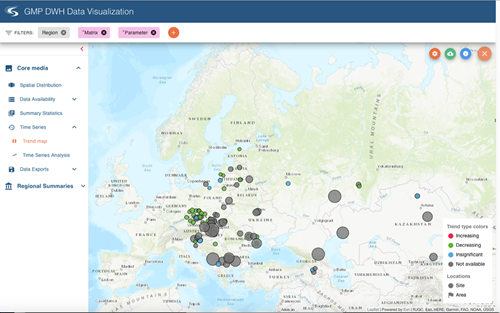
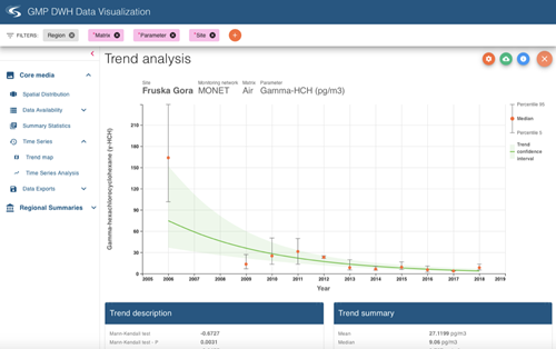
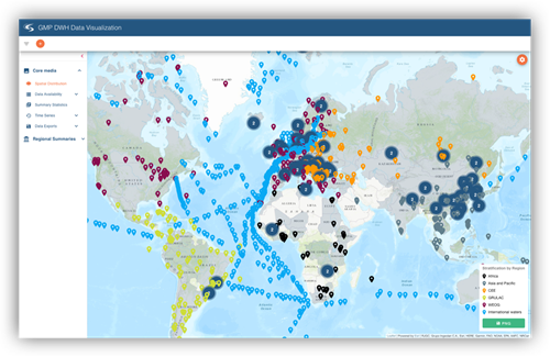
RECETOX is a key partner of GEO, together with the Secretariat of the Stockholm Convention on POPs, in the priority area of health. As part of this cooperation, we are therefore developing tools for worldwide collection, data analysis and visualization of POPs levels and trends, as part of the management of the GOS4POPs initiative included in the GEO work plan. We not only perform regular collection, subsequent analysis, interpretation and visualization of this data, but we also make it available to the public and connect it to GEOSS. Consolidated regional / continental reports and a global report are produced every 6 years. The regional reports will be available in spring 2021, the global report will be completed in December 2021. Once the Stockholm Convention's highest decision-making body approves the individual continental reports, the data will be available in the GMP DWH repository for free use by scientists, policy makers and the general public. Currently, access to the visualization portal is only possible for expert teams that prepare reports for individual continents. After making it accessible, we will also expand the user base by connecting the global database on POPs created in RECETOX (www.pops-gmp.org) to GEOSS in the field of health protection.
The great success of our database has been the arrangement of global availability of data on the occurrence of POPs from various sources, monitoring programs and research projects so that the data are standardized, comparable and validated. It is not just the level of concentration of a substance and its change over time but a range of additional information that is necessary to understand the behaviour of toxic substances in the environment that subsequently lead to better measures to protect our health and the environment at national level, in Europe and worldwide. In addition, the GMP DWH database contains in one place complete data on human POPs from almost thirty years of study around the world and is used by individual countries and international organizations - the World Health Organization (WHO), the United Nations Environment Program (UNEP) and for Agriculture and Food (FAO). And the use is also aided by a user-friendly data portal with maps, graphs and tabular outputs.
This does not end the listing of RECETOX efforts in the field of remote sensing of the Earth. RECETOX is implementing one of the largest European projects, the e-shape project, aimed at increasing the use of Earth observation data through new services, portals, models and applications. There is also the Maturity Cards initiative within e-shape. It provides the public with a picture of the level of capacities and experience of the participating states. RECETOX on behalf of the Czech Republic coordinates the creation of this card of national capacities and works closely with the National Secretariat of GEO / Copernicus, the coordinating body of GEO activities in the Czech Republic.
Kateřina Šebková, coordinator of the e-shape project at RECETOX, adds: “The e-shape project is focused not only on expanding the use of data and services in an interdisciplinary manner, but also creates the so-called Euro-GEO. The EU is a world leader in remote sensing and spends hundreds of millions of euros on its programs (e.g. Copernicus), providing practical solutions for users at local, urban, national and continental levels. There is therefore a need to promote more the EU activities under the GEO. We are glad that, as RECETOX, we have been contributing to GEO for a long time and we see interdisciplinary overlap and use. In addition to building a global environmental database GMP DWH for health, we will use information from satellites and data on climate change and weather in the research of the urban exhibition within the European project URBAN-X. It is in this area that we see other opportunities for the development of collaboration and new applications."
GEO is an international initiative involving over 100 states and more than 100 intergovernmental, international and regional organizations. Its main goal is to coordinate remote sensing activities and create a signpost to integrate observation systems and ensure data sharing. The Czech Republic has been a member since 2009 and RECETOX will become an associate member by the end of this year.
The e-shape project was supported by the EU Horizon 2020 research program project No. 820852.
Source: visualization GMP DWH (dmc.pops-gmp.org, restricted access/authorized persons only)


